No products
Shetland Maps
- Latest Releases
- Signed Copy Event Pre-orders
- Orkney Guidebooks, Travel Books & Maps
- Calendars, Gifts & Souvenirs
- Orkney Christmas Cards
- Orkney Fiction, Poetry, Folklore & Myths
- George Mackay Brown
- Children's
- Local Author - non-Orkney Related Titles
- Orkney Life, People & Places
- Orkney History
- Maritime
- Photos, Art, Music, Food & Sport
- Nature
- Shetland Books & Maps
- Sale
- 'The Orcadian' Subscriptions
Shetland Maps There are 15 products.
-
Footprint Discover The Shetland Islands Map
Visitor Map Visitor attractions - History - Wildlife - Transport This map is the perfect companion to take for exploring the Shetland Islands. Scale 1:120,000 Waterproof.
£ 9.95 -
Orkney & Shetland - OS Pathfinder Book -...
Ordnance Survey Pathfinder series. Outstanding Circular Walks in Orkney & Shetland. - 28 Great country walks from 1 3/4 to 6 3/4 miles. - Clear, large scale Ordnance Survey route maps. - GPS references for all routes. Paperback book.
£ 12.99 -
Shetland Pocket Map
Collins Shetland pocket map. The perfect way to explore the Shetland Islands.
£ 3.99 -
Scotland - OS Tour Map
Ordnance Survey Tour Map Scotland, including islands 1:500 000 scale 1cm to 5km - 1 inch to 8 miles
£ 6.99 -
Northern Scotland, Orkney & Shetland - 1 -...
Ordnance Survey Map. Northern Scotland, Orkney & Shetland, 1, OS Road Map. 1:250 000 scale, 1cm to 2.5km - 1 inch to 4 miles.
£ 7.99 -
Philip's Orkney & Shetland Leisure Map
Leisure and tourist map featuring places of tourist and historic interest. Orkney and Shetland. 1:160 000 scale. 2 1/2 miles to 1 inch.
£ 6.99 -
Shetland - Unst, Yell and Fetlar - 470 -...
Ordnance Survey Explorer Series Map Shetland - covering Unst, Yell & Fetlar. 1:25 000 4cm to 1km - 2 1/2 inches to 1 mile
£ 12.99 -
Shetland - Mainland North West - 469 - OS...
Ordnance Survey Explorer Series Map Shetland - Mainland North West - covering North Roe & Sullom Voe. 1:25 000 4cm to 1km - 2 1/2 inches to 1 mile
£ 12.99 -
Shetland - Mainland North East - 468 - OS...
Ordnance Survey Explorer Series Map Shetland - Mainland North East - covering Whalsay & Out Skerries. 1:25 000 4cm to 1km - 2 1/2 inches to 1 mile
£ 12.99 -
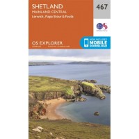
Shetland - Mainland Central - 467 - OS...
Ordnance Survey Explorer Series Map Shetland - Mainland Central - covering Lerwick, Papa Stour and Foula. 1:25 000 4cm to 1km - 2 1/2 inches to 1 mile
£ 12.99 -
Shetland - Mainland South - 466 - OS...
Ordnance Survey Explorer Series Map Shetland - Mainland South - covering Lerwick, Sumburgh & Fair Isle. 1:25 000 4cm to 1km - 2 1/2 inches to 1 mile
£ 12.99 -
Shetland - South Mainland - 4 - OS...
Ordnance Survey Landranger Series Map. Shetland - covering South Mainland. 1:50 000 2cm to 1km - 1 1/4 inches to 1 mile
£ 12.99


