No products
Shetland Books & Maps
- Latest Releases
- Signed Copy Event Pre-orders
- Orkney Guidebooks, Travel Books & Maps
- Calendars, Gifts & Souvenirs
- Orkney Christmas Cards
- Orkney Fiction, Poetry, Folklore & Myths
- George Mackay Brown
- Children's
- Local Author - non-Orkney Related Titles
- Orkney Life, People & Places
- Orkney History
- Maritime
- Photos, Art, Music, Food & Sport
- Nature
- Shetland Books & Maps
- Sale
- 'The Orcadian' Subscriptions
Shetland Books & Maps There are 33 products.
Subcategories
-
Shetland - Unst, Yell and Fetlar - 470 -...
Ordnance Survey Explorer Series Map Shetland - covering Unst, Yell & Fetlar. 1:25 000 4cm to 1km - 2 1/2 inches to 1 mile
£ 12.99 -
Shetland - Mainland North West - 469 - OS...
Ordnance Survey Explorer Series Map Shetland - Mainland North West - covering North Roe & Sullom Voe. 1:25 000 4cm to 1km - 2 1/2 inches to 1 mile
£ 12.99 -
Shetland - Mainland North East - 468 - OS...
Ordnance Survey Explorer Series Map Shetland - Mainland North East - covering Whalsay & Out Skerries. 1:25 000 4cm to 1km - 2 1/2 inches to 1 mile
£ 12.99 -
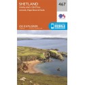
Shetland - Mainland Central - 467 - OS...
Ordnance Survey Explorer Series Map Shetland - Mainland Central - covering Lerwick, Papa Stour and Foula. 1:25 000 4cm to 1km - 2 1/2 inches to 1 mile
£ 12.99 -
Shetland - Mainland South - 466 - OS...
Ordnance Survey Explorer Series Map Shetland - Mainland South - covering Lerwick, Sumburgh & Fair Isle. 1:25 000 4cm to 1km - 2 1/2 inches to 1 mile
£ 12.99 -
Shetland - South Mainland - 4 - OS...
Ordnance Survey Landranger Series Map. Shetland - covering South Mainland. 1:50 000 2cm to 1km - 1 1/4 inches to 1 mile
£ 12.99 -
Shetland - North Mainland - 3 - OS...
Ordnance Survey Landranger Series Map. Shetland - covering North Mainland. 1:50 000 2cm to 1km - 1 1/4 inches to 1 mile
£ 12.99 -
Shetland - Sullom Voe and Whalsay - 2 - OS...
Ordnance Survey Landranger Series Map. Shetland - covering Sullom Voe & Whalsay. 1:50 000 2cm to 1km - 1 1/4 inches to 1 mile
£ 12.99 -
Shetland - Yell, Unst and Fetlar - 1 - OS...
Ordnance Survey Landranger Series Map. Shetland - covering Yell, Unst & Fetlar. 1:50 000 2cm to 1km - 1 1/4 inches to 1 mile
£ 12.99


